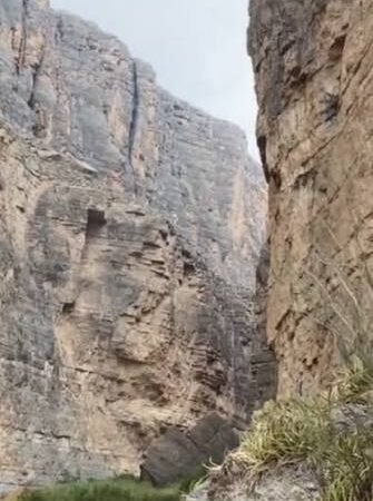
Sanderson, Texas, is a town shaped by the land around it.
Visitors driving into town on U.S. Highway 90 quickly notice the rugged terrain, desert vegetation, rocky hills, and broad open country surrounding the community. Sanderson is not simply a town placed on a map in far West Texas. Its location in Sanderson Canyon has influenced travel, ranching, railroad construction, flood danger, and the character of the town for well over a century.
To understand Sanderson, it helps to look beyond the buildings, highways, and rail line. The canyon itself is part of the story.
What Is Sanderson Canyon?
Sanderson Canyon is a long valley and intermittent stream system that runs through portions of Brewster and Terrell counties before eventually reaching the Rio Grande. It includes a network of tributaries, draws, and dry washes that carry water during periods of heavy rain.
For much of the year, these channels may appear dry or nearly dry. But during major storms, water can move through this country quickly and with tremendous force.
The canyon crosses rugged limestone country, with areas of sand, gravel, mud, and alluvial deposits. The surrounding terrain supports familiar West Texas vegetation, including mesquite, juniper, grasses, and cactus. Together, the rock, soil, desert plants, and seasonal watercourses give the country around Sanderson its distinctive Trans-Pecos character.
The canyon and the town share the same name, and they have long shared the same history.
A Hard Country to Cross
Long before modern highways and air-conditioned vehicles, far West Texas was difficult country to travel.
The distances between settlements were great. Dependable water could be scarce. Summer heat, rough terrain, and sudden storms made travel challenging for anyone moving through the region.
Canyon country could provide routes through the landscape, but it also created obstacles. Travelers, ranchers, freight haulers, and later railroad crews had to deal with rocky ground, changing elevations, washouts, heat, and weather.
This geography helped shape the practical decisions that led to the development of Sanderson. A transportation route through this part of Texas needed workable terrain, access to supplies, and a place where people could live, work, and build a community around travel and commerce.
The Railroad Made Sanderson a Town
Sanderson’s modern history is closely tied to railroad construction in the early 1880s.
The community developed as a railroad division point on the Southern Pacific route. The construction of railroad facilities, including a roundhouse, helped establish Sanderson as a permanent railroad town.
The railroad connected Sanderson to a much larger world. It brought workers, mail, supplies, passengers, and freight through a region that had previously been defined by distance and isolation. It also gave local ranchers a way to move cattle, sheep, wool, mohair, and other products toward larger markets.
But the railroad had to work with the land, not against it.
The route through canyon country required planning, construction, maintenance, and constant attention to weather. In a dry region, water may seem like a rare problem—until it arrives all at once.
When Dry Country Becomes Dangerous
One of the most important facts about canyon country is that dry ground does not always mean safe ground during a storm.
West Texas weather can change quickly. A thunderstorm falling upstream or in nearby higher terrain can send water rushing into normally dry channels, draws, and arroyos. Water gathers, accelerates, and follows the natural shape of the land toward lower ground.
That reality became painfully clear in Sanderson on June 11, 1965.
Heavy rain over Sanderson Canyon sent a flash flood into town. A wall of water tore through the community, destroying homes and businesses and taking the lives of 26 people. The disaster remains one of the defining events in Sanderson’s history.
The 1965 flood was not just a weather event. It showed how closely the town’s future was tied to the geography around it. The canyon that shaped travel, settlement, and the railroad corridor also directed water toward Sanderson when intense rainfall struck the watershed.
In the years after the flood, flood-control dams were built upstream to help reduce the danger of another catastrophe.
The story remains an important reminder that the beauty of the land around Sanderson is matched by its power.
The Canyon Remains Part of Daily Life
Today, Sanderson Canyon is still part of the town’s identity, even when its channels are dry.
The surrounding terrain affects the views people see every day. It helps define the approach into town. It influences weather awareness, road conditions, drainage, ranching, photography, and the feeling of being in a remote but deeply connected part of West Texas.
The canyon country also helps explain why Sanderson appeals to travelers.
People driving between Del Rio and El Paso, exploring the Trans-Pecos, or heading toward the Big Bend region often find that Sanderson feels different from a typical highway stop. The town sits in a landscape with depth, history, and visible evidence of the natural forces that shaped it.
For photographers, the best views often come early or late in the day, when low sunlight brings out the texture of limestone hills, desert plants, rail lines, and open country. After rain, the landscape can change again, with greener vegetation, dramatic skies, and flowing water in places that are usually dry.
Sanderson Canyon and the Cactus Capital
Sanderson is known as the Cactus Capital of Texas, and the canyon landscape is part of the reason that identity feels natural here.
The dry climate, rocky soils, open terrain, and desert vegetation all contribute to the scenery that residents and visitors associate with Sanderson. Cactus, mesquite, grasses, limestone, and wide horizons are not just background scenery. They are part of the setting that has shaped how people live, work, travel, and remember this part of Texas.
The town’s cactus identity is more than a slogan. It reflects the land itself.
What Visitors Should Notice
A visit to Sanderson is more meaningful when you take a moment to notice the terrain around town.
- Watch the changing landscape as you approach Sanderson on U.S. Highway 90.
- Look for the draws, washes, and natural drainage routes that cross the surrounding country.
- Notice how the railroad corridor follows the geography of the region.
- Photograph the hills, cactus, clouds, and desert light from safe public locations.
- Visit local historical sites and the visitor center to learn more about the area’s past.
- Treat flood channels and low-water crossings with respect, especially during storms or periods of heavy rain.
The land around Sanderson is beautiful, but it is also powerful. The same country that offers wide views, dramatic skies, and quiet desert scenery can change quickly during severe weather.
A Town Connected to Its Landscape
Sanderson’s story is often told through railroads, ranches, old buildings, community traditions, and the people who call this part of Texas home.
But beneath all of those stories is the land.
Sanderson Canyon shaped the routes people traveled. It influenced where the railroad came through. It helped determine how the town grew. It has brought both beauty and danger to the community. And it remains one of the clearest reminders that Sanderson is a place where geography still matters.
For visitors, the canyon provides a deeper way to see the town. For residents, it is part of the landscape that has always been there—sometimes quiet, sometimes harsh, always memorable.
Sanderson was built by people, but it was shaped by the country around it.